


‘The Canoe and The Saddle.’ A 19th Century Traveler on the Pacific Northwest and Renaming Land and Sea
Theodore Winthrop described how history and identity are rewritten by renaming. His was an inward journey as well, replete with aesthetic observations worth remembering.


In August 1853, a 24-year-old traveler from New Haven, Connecticut, named Theodore Winthrop paddled in a 40-foot dugout canoe 65 miles from Port Townsend at the northern entrance of Puget Sound to the mouth of the Nisqually River at the southern end, where he bought Indian horses and rode over the shoulders of Mount Rainier and across the Columbia River to join an escort heading back east. He covered nearly 300 miles in 11 days and wrote all about it in his book, “The Canoe and the Saddle,” published in 1862.
Winthrop was unusual for his time. He had traveled to the new state of California and the territories of Oregon, Washington, and British Columbia strictly as a tourist, absorbing the beauty of the West far more than its commercial potential at a time when it was still being mapped. It was only in 1846 that the British had given up control of the Pacific Northwest by treaty after the Russians left California in 1841, but before Mexico did in 1848. Seattle’s first settlers arrived just two years before Winthrop, in 1850.
He wrote at length about the effect the landscape had on him, an aristocratic Puritan and Yale law graduate, fully unprepared for the magnitude of the West with its enormous ancient forests and mountains, and the mythic characters who populated it. For Winthrop, it was like traveling back in time.
I had wanted to make the same boat journey myself since reading Winthrop’s story when I moved to the shores of Puget Sound from the East Coast in 1991. The landscape had cast its spell on me then, and I wanted to see what of it he so admired might have survived. Finally, in April 1999, I climbed into my kayak and followed in his wake.
Port Townsend to Fort Flagler
It did not start well. I had intended an easy first day riding the flood current a scant 9 miles from Port Townsend at the northern end of Puget Sound to Whidbey Island on the eastern side. Instead, I paddled into a 20-knot wind and two-foot waves for 90 minutes to make three miles. I stopped at a campsite out of the wind on Marrowstone Island, below the cliffs of Fort Flagler. The wind kept blowing but the sun came out as I lazily counted horned grebes, Harlequin ducks, hooded mergansers, and the occasional loon wandering up the shoreline.
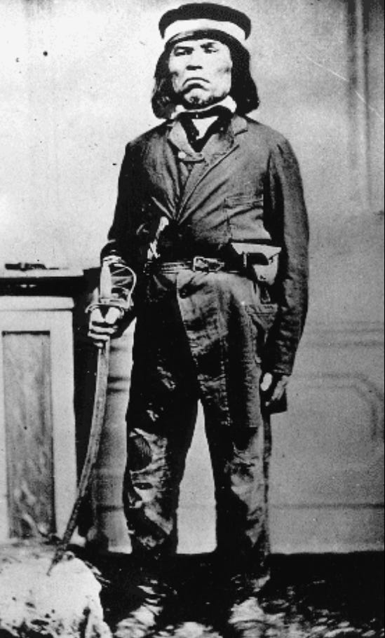
It was August 21, 1853, when Winthrop was in Port Townsend, which he called “A town of one house on a grand bluff, and one sawmill in a black ravine.” The British captain George Vancouver named the sheltered bight that became Port Townsend himself in 1792, but it wasn’t settled by whites until 1851, two years before Winthrop’s arrival. He met a local S’Klallam chief named Chetzemoka, pronounced “Cheech-ma-han,” though that hardly mattered since he was known derisively as the Duke of York for what was seen as his pretensions. After a difficult interview, Winthrop managed to hire a canoe with Chetzemoka as pilot and half a dozen paddlers for a blanket a piece. Despite his own pompous attitude, Winthrop was enthralled. “Moments now,” he wrote, “were worth days of common life.”
Fort Flagler to Oak Bay
My night was interrupted several times by wind crashing through the trees like breakers and rain hammering against my tent. Conditions had not improved by morning and rather than face the Sound, I decided on a sneak route through the Port Townsend Portage Canal dug in 1913 through the isthmus connecting Indian and Marrowstone Islands to the Quimper Peninsula. This meant backtracking a few miles, but it was a sheltered route with the morning flood in the lee of an island covered with stands of trees wrapped in mist. I still ended up paddling into a wet breeze for a couple of hours just to cover five miles.
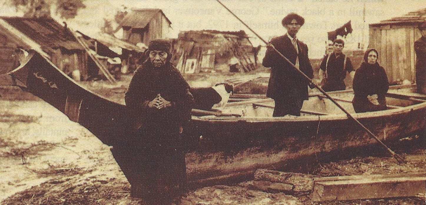
Puget Sound is an enormous estuary, about 65 miles long and 35 across, containing a network of channels, bays, and islands. Nearly mile-high glaciers carved a pattern of long canyons backed by cliffs of glacial till 14,000 years ago, leaving an inland coastline nearly 2,000 miles long. Ocean current floods through the Strait of Juan de Fuca south into the Sound, and returns to the sea twice a day like an enormous river changing direction. And, like a river, water rushes through the narrow channels, around islands and over shoals, creating rapids, eddies and tide rips. The Coast Salish peoples who appeared about 10,000 years ago called Puget Sound “whulge,” an anglicized word loosely translated as “big salt water.” But it also poetically echoes the sound of rushing water or waves along the shore.
In any case, it was a name much more to Winthrop’s liking.
“Tides in whulge, which the uneducated maps call Puget’s Sound, rushed with impetus, rising and falling 18 or 20 feet ... Whulge is a vast fjord, parting rocks and forest primeval with a mighty tide. Chesapeakes and the like do very well for oyster fundums and shad-fisheries, but whulge has a picturesque significance as much greater as its salmon are superior to the osseous shad of the East.”
I camped on a long jetty that divides the mudflat of Oak Bay from a salt marsh and pond where about 100 black brants, pintails, and buffleheads were sheltering from the wind. I baked a slab of salmon in my Dutch oven and spent another night listening to the rain and the cries of coyotes on the wind.
At daylight, steep whitecaps stretched to the grey horizon. I was looking at a current-assisted but upwind paddle of about 20 miles to the next campsite.
Winthrop, Chetzemoka, and crew by contrast must have made 30 miles on their first day. “We swept along through narrow straits between piney islands and by sheltered bays where fleets might lie hidden.” Part of this journey was made at the point of Winthrop’s revolver, however, which may account for the pace. He was quick to suspect Chetzemoka of treachery, even while recognizing the destruction of his people through disease and alcohol, developments that had long since transformed the landscape in Winthrop’s New England. Another writer of the time, Washington pioneer James G. Swan, considered Chetzemoka a friend and a good man even before his actions to prevent violence during the Indian War, which in 1853 was just below the horizon.
But for the moment, as Winthrop wrote, “Those were prosperous days in the Pacific. Indian Whulgeamish and Yankee Whulgers were reasonably polite to each other and the Pacific Railway was to be built straight away ... Many lumber vessels were drifting or at anchor under the opposite shore, loaded mainly with fir trees soon to be drowned as piles for San Francisco docks.” Sharing dinner under the stars with his paddlers, Winthrop was moved to write that “wretched ... is he who cannot adapt himself to the dreams and hopes, the awes and pleasures of this life.”
Oak Bay to Blake Island
I launched before the south-flowing flood, sharing the water only with the aircraft carrier Abraham Lincoln, which overtook me on her way to the shipyards at Bremerton. I paused to drift over the shallow ridge of Restoration Point at the southeast corner of Bainbridge Island, across from Seattle. This is where Vancouver anchored his ship, the Discovery, on May 20, 1792, and dispatched his first Lieutenant, Peter Puget, to survey the surrounding waters in an open boat looking for signs of the Northwest Passage. Puget returned to the ship on the 27th, having investigated nearly every inlet in the South Sound and concluding there was no passage, here at any rate.
I landed on the southwestern corner of Blake Island, the ancestral camp and hunting ground of the Suquamish, and thought to be the birthplace of Chief Si’ahl around 1780, whose anglicized name — Seattle — would be given to the new settlement across the water. Not long before my visit, almost 30 resident orcas swam by this island chasing a salmon run, but all I saw were mice and owls.
Blake Island to Steilacoom
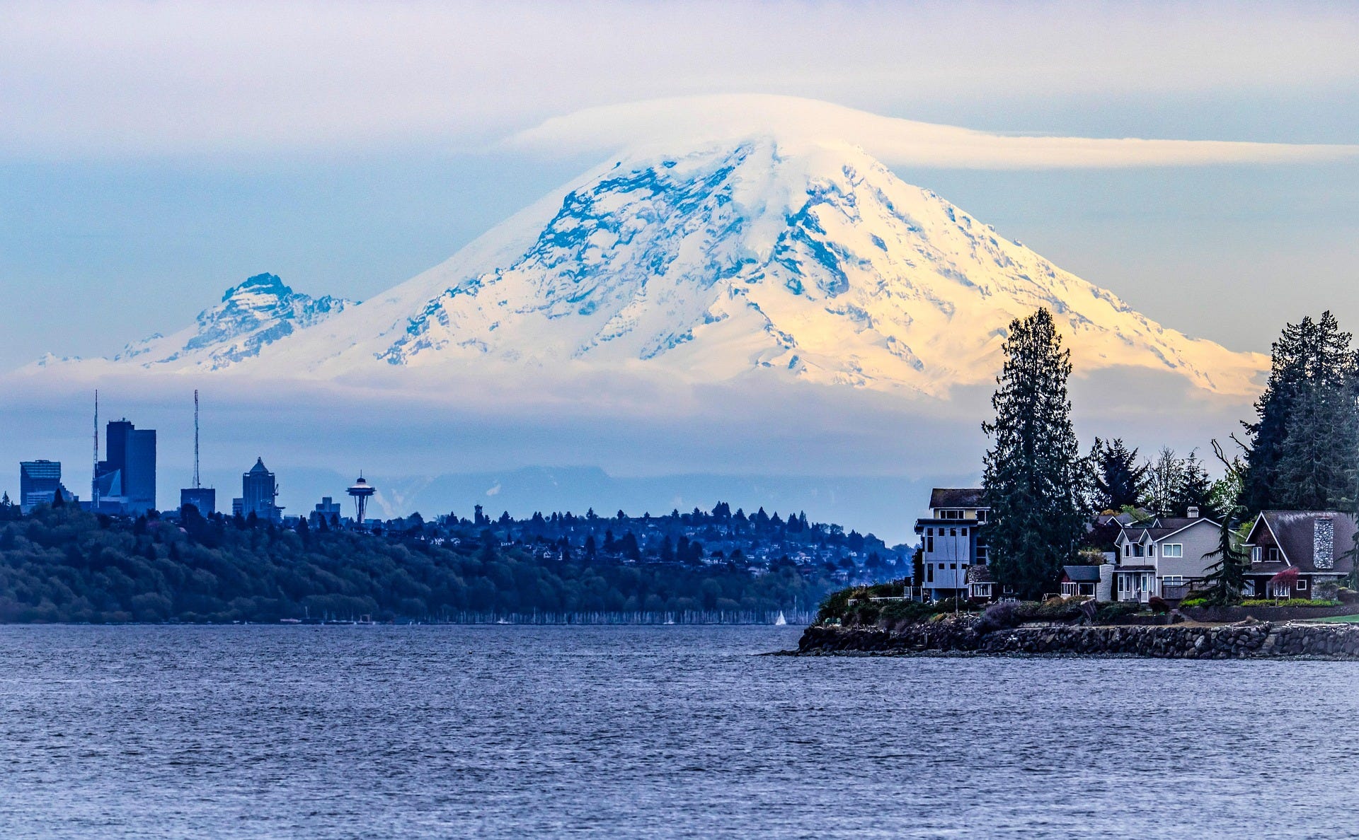
“We had rounded a point and opened Puyallup Bay, a breadth of sheltered calmness, when I, lifting sleepy eyelids for a dreamy stare about, was suddenly aware of a vast shadow in the water ... Kingly and alone stood this majesty, without any visible comrade or consort ... Mount Rainier, Christians have dubbed it, perpetuating the name of somebody or nobody. More melodiously, the Indians call it Tacoma.”
I too had my first glimpse of Rainier in several days, emerging from Colvos Passage at the south end of Vashon Island. Rainier stands alone, a solitary volcanic cone 14,411 feet tall, the largest and most heavily glaciated mountain in the Lower 48. I was paddling around the tide rip below Point Defiance to catch a free ride on the flood through the Tacoma Narrows, where the current would reach 5 knots that day. Rainier’s dome was barely visible above a line of dark clouds heading toward me out of the south.
“Mountains should not be insulted by being named after undistinguished bipeds,” wrote Winthrop, “nor by the prefix ‘mount’ ... That seems as feeble as Mr. Julius Caesar or Signor Dante.”
Even so, Winthrop mistook the local Lushootseed name for Mount Rainier. The closest variation was tah-ho-mah, meaning “great snowy mountain,” or “one who touches the sky.” But he never missed a chance to admire it.
“When a vista opened eastward, Tacoma appeared above the low-lying mists of the distance ... We are poorly off for such objects east of the Mississippi ... never among them one single summit brilliant forever with snow, golden in sunshine, silver when sunshine has gone, lustrous white over leagues of woodland.”
I met up with friends at the public launch at Steilacoom near sunset, having averaged 5 knots in the morning and 2 in the afternoon. Steilacoom was a military post a mile inland from whulge in Winthrop’s time, and had a port on the Sound consisting of one warehouse, “where every requisite of pioneer life was to be had.” Winthrop stopped here only long enough to pick up a friend’s saddle and some dried pork and hardtack. “Here I heard first the mighty name of Owhi, the chief of the feared mountain horsemen.” Owhi was another man with a role to play in Northwest history, but for now he was at Fort Nisqually, Winthrop’s destination, and had horses to trade.
Steilacoom to Nisqually
Fort Nisqually was built by the Hudson’s Bay Company north of the Nisqually River, which flows from a glacier on Rainier, in 1833 as an outpost for the fur trade that lured explorers and trappers across the continent. This trade was exhausted by Winthrop’s time and the old HBC fort was surviving on business in agriculture and livestock. It was the first Anglo outpost in the Pacific Northwest and remained in British hands until 1869.
“To visit such a place is to recall and illustrate all our early New England history ... pioneers flew from cabin and clearing to stockades far less defensible than this, escaping the scoffing yell of Indians, contemptuous victors over the race that scorned them ... We can hardly now connect ourselves with that period ... This palisade fort was a monument of a past age to me.”
Within two years, the same stockade would shelter settlers as history repeated itself.
Winthrop spent one night in Nisqually, bartering with Owhi for horses and supplies for his 230-odd-mile ride across the southern shoulder of Rainier to the Dalles in Oregon. Owhi was a Yakama chief who had come over the Cascade Mountain range to the east, and he described to Winthrop at length details of the route he needed to take. Of him, Winthrop simply wrote, “Dignity tells.”
The next day, Winthrop set off for the Dalles with three of Owhi’s horses and one of his sons as a guide. “I looked my last upon sturdy tides of whulge and led the way under the oaks.”
The remains of the old fort were moved inland in the 1930s, so I thought a more fitting end to my journey would be within the Nisqually Delta itself, on McCallister Creek. Strands of saltwater sloughs thread through vast marsh and mudflats here, a haven for young salmon and crabs and hundreds of species of resident and migratory birds. I drifted south along the shoreline, dense with tangled green alder and red-barked madrona. Mist rose to the low clouds in columns from the woods like smoke from ghostly campfires. Harbor seals appeared near the mouth of the creek, silent heads rising through the surface to watch my passage. I spotted half a dozen bald eagles and a few great blue herons perched on snags and stumps, all motionless and silent, waiting for the tide to drop and expose their prey. And always before me was Rainier, the largest mountain Winthrop had ever seen and that embodied the emotions inspired by his journey.
“Our lives forever demand and need visual images that can be symbols to us of the grandeur or sweetness of repose ... and studying the light in the majesty of Tacoma, there passed from it and entered into my being ... a thought and an image of solemn beauty, which I could thenceforth evoke whenever in the world I must have peace.”
I beached the kayak about a mile up the creek where there was a lone and long-dead Douglas fir, the last of a stand cut down in 1963 to make way for Interstate 5. It was near where the Medicine Creek Treaty was signed by Washington Territorial Governor Isaac Stevens and chiefs of the local Nisqually, Puyallup, and Squaxin tribes in December 1854. Chief Leschi of the Nisqually refused to sign and tried to stop the others, saying that if they traded their freedom for reservation life there would be no end to the whites’ encroachment.
War broke out soon after, and within three years Leschi and Owhi and his sons were all dead, together with many others. The killing did not stop until the treaty was renegotiated. The Lushootseed name for the area, shwh-nah-num, must portend something greater than the roughly translated Medicine Creek, a name later changed to McAllister Creek for James McAllister, one of the first whites killed in the conflict. Chetzemoka, the canoe pilot Winthrop so distrusted, spent the war intervening between his people and the whites instead of fighting them, earning such gratitude from the residents of Port Townsend that they built him a monument.
Theodore Winthrop never returned to the Pacific Northwest. Of his journey, the 24-year-old Puritan wrote, “I had a serene sense of new and large experience and of some qualities in myself newly tested ... For such emotion, years of pilgrimage were worthily spent.”
Winthrop went back to the East Coast to become an attorney and an abolitionist. He was a major in the 7th Regiment of the New York State Militia and killed in action June 10, 1861, during the first battle of the Civil War in Virginia, before his book was published. He was 33 years old.
A red-tailed hawk perched near the top of the Medicine Creek tree never moved during my stop, or when I returned to my kayak. I drifted back downstream. It was not difficult in this place to feel the spell cast on Winthrop; to imagine the ancient voices and new languages he heard amid the enormous patriarchs of trees that surrounded this inland sea. Still, even under the gray sky and flat winter light, I could see Mount Rainier looming behind us, the source of the Nisqually River and home to a glacier now called Winthrop, named to commemorate a man who, had he known of the honor, would certainly have refused it.
First published in a different form in Canoe & Kayak, August 1999.